Upsc insights
Welcome to my UPSC learning space — where I share clear, concise, and thoughtful blogs on Polity, History, Geography, and Economics. Learn, revise, and stay inspired for your civil services journey.
Welcome to my UPSC learning space — where I share clear, concise, and thoughtful blogs on Polity, History, Geography, and Economics. Learn, revise, and stay inspired for your civil services journey.
Welcome to my UPSC learning space — where I share clear, concise, and thoughtful blogs on Polity, History, Geography, and Economics. Learn, revise, and stay inspired for your civil services journey.
The Ganga river system is one of the most important river systems in India. It is not just a river network; it is the backbone of northern India’s geography, economy, agriculture, and culture. For UPSC aspirants and other competitive exam students, understanding the Ganga river system is crucial from both physical geography and socio-economic perspectives.
In this blog, we will explore the origin, course, tributaries, features, and importance of the Ganga river system in simple and clear language.
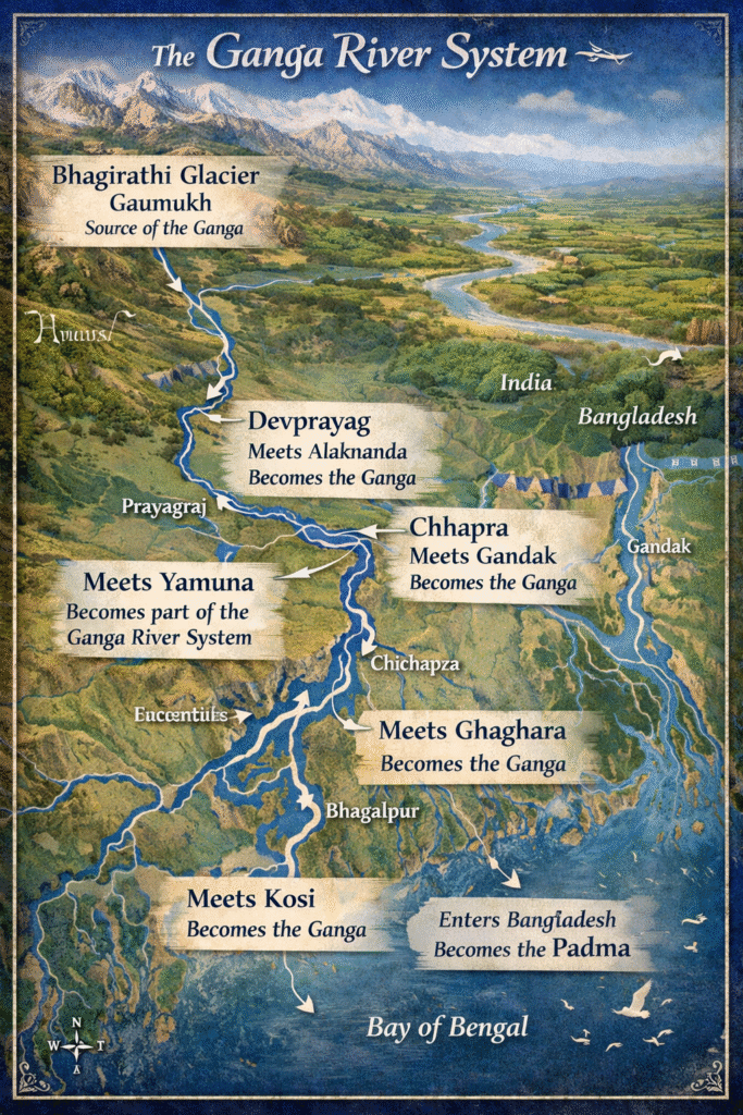
The Ganga river system begins in the Himalayas. The river Ganga originates as the Bhagirathi from the Gangotri Glacier at Gaumukh in Uttarakhand. At Devprayag, the Bhagirathi meets the Alaknanda, and from there it is officially known as the Ganga.
The river then flows through the states of Uttarakhand, Uttar Pradesh, Bihar, Jharkhand, and West Bengal before entering Bangladesh, where it is called the Padma.
Finally, it drains into the Bay of Bengal, forming a massive delta.
The Ganga river system is made up of many important tributaries. These tributaries increase the water volume and make the basin one of the largest in India.
Among these, the Kosi is known as the “Sorrow of Bihar” because of its frequent floods and shifting course.
The Yamuna is the largest right-bank tributary. It originates from the Yamunotri Glacier and joins the Ganga at Prayagraj (Allahabad), forming the famous Triveni Sangam.
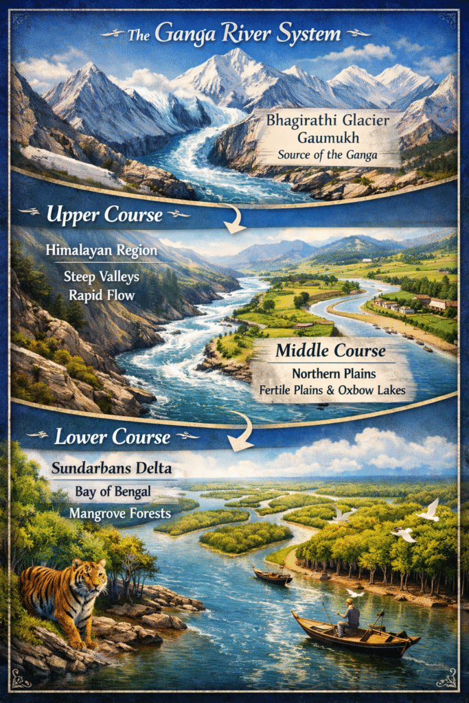
The Ganga river system can be divided into three parts:
In the mountainous region, the river flows swiftly with a steep gradient. It forms deep valleys, rapids, and gorges. This stage is mainly erosional in nature.
After entering the plains at Haridwar, the river slows down. It begins to deposit sediments and forms features like meanders, oxbow lakes, and floodplains. This region is extremely fertile because of alluvial soil.
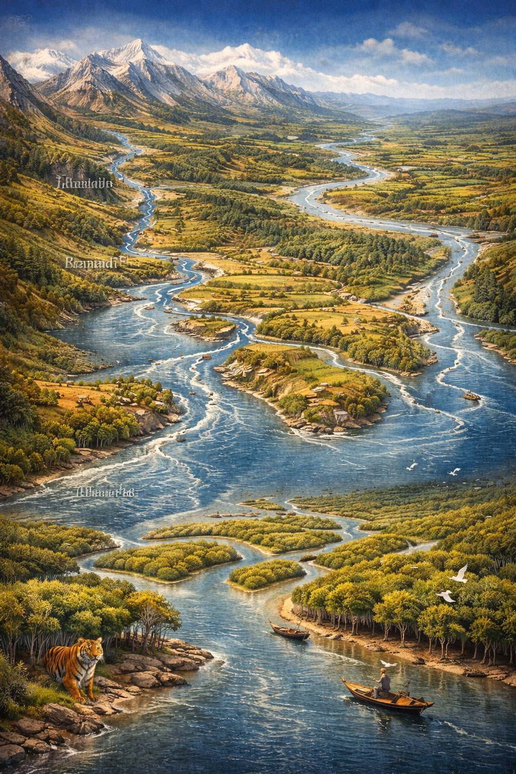
In West Bengal, the river divides into distributaries and forms the world’s largest delta — the Sundarbans Delta. This delta is shared between India and Bangladesh and is famous for mangrove forests.
The Ganga river system has one of the largest drainage basins in the world. In India, it covers parts of:
The basin supports a large population and is highly significant for agriculture.
The Ganga basin has fertile alluvial soil, which is ideal for crops like rice, wheat, sugarcane, and pulses. The river provides irrigation facilities to millions of farmers.
The Ganga river system supports industries, fisheries, and inland water transport. National Waterway-1 runs along the Ganga, connecting Allahabad (Prayagraj) to Haldia.
The Ganga is considered sacred in Hinduism. Cities like Varanasi, Haridwar, and Prayagraj are located along its banks. Millions of people perform religious rituals in the river.
The river supports various species such as the Gangetic dolphin, which is India’s national aquatic animal. The Sundarbans delta is home to the Royal Bengal Tiger.
Despite its importance, the Ganga river system faces several challenges:
To address these issues, the government launched the Namami Gange Programme for cleaning and conserving the river.
Flooding is a common problem in the Ganga river system, especially in Bihar and eastern Uttar Pradesh. Rivers like the Kosi and Ghaghara frequently overflow during the monsoon season. The flat plains and heavy rainfall increase flood risks.
Floods bring fertile silt but also cause damage to crops, homes, and infrastructure.
For UPSC preparation, the Ganga river system is important in:
Understanding maps and tributaries is essential for both Prelims and Mains.
The Ganga river system is truly the lifeline of northern India. It shapes the land, supports agriculture, sustains millions of people, and holds deep cultural significance. From its origin in the Himalayas to its vast delta in the Bay of Bengal, the Ganga plays a central role in India’s geography.
However, with increasing pollution and environmental pressure, protecting this river system has become more important than ever. Sustainable management and public awareness are necessary to preserve the Ganga river system for future generations.
If you are preparing for UPSC or any competitive exam, make sure you understand the origin, tributaries, drainage basin, and importance of the Ganga river system clearly. It is a topic that connects geography, economy, environment, and culture in one integrated framework.