Upsc insights
Welcome to my UPSC learning space — where I share clear, concise, and thoughtful blogs on Polity, History, Geography, and Economics. Learn, revise, and stay inspired for your civil services journey.
Welcome to my UPSC learning space — where I share clear, concise, and thoughtful blogs on Polity, History, Geography, and Economics. Learn, revise, and stay inspired for your civil services journey.
Welcome to my UPSC learning space — where I share clear, concise, and thoughtful blogs on Polity, History, Geography, and Economics. Learn, revise, and stay inspired for your civil services journey.

The Indian monsoon is not driven only by surface heating and pressure differences. A major part of its behavior is controlled high above the Earth’s surface by fast-moving air currents known as jet streams. Understanding the role of jet streams in Indian monsoon helps explain why the monsoon arrives suddenly, why it sometimes weakens, and how rainfall distribution changes across regions.
Jet streams act as atmospheric steering mechanisms that influence wind patterns, pressure systems, and the seasonal shift of rainfall.
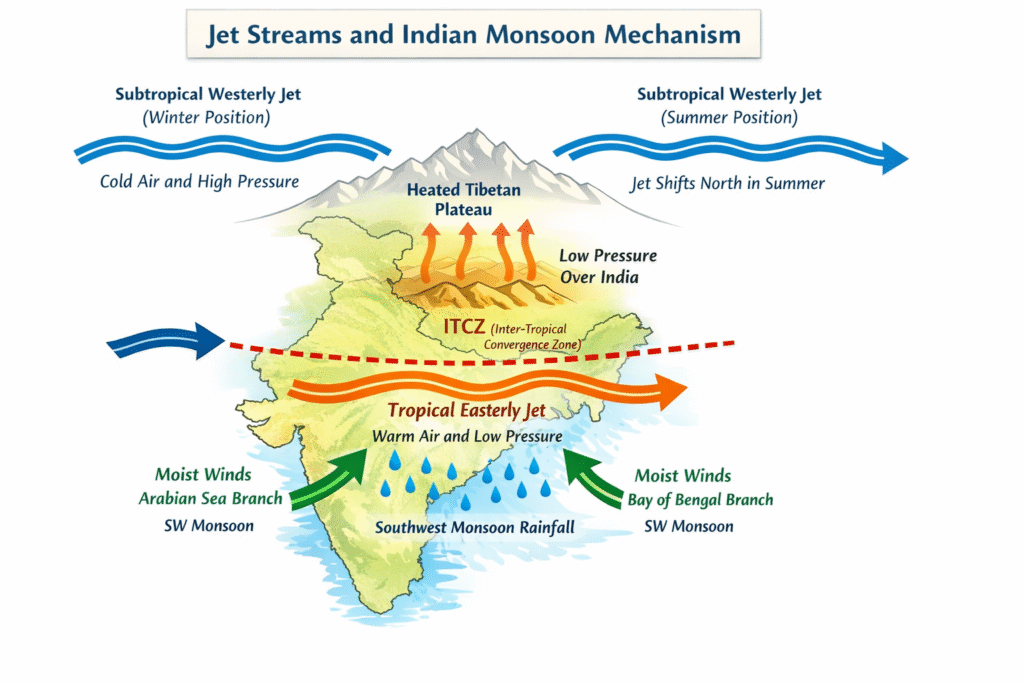
Jet streams are narrow bands of very strong winds flowing in the upper troposphere, usually at an altitude of 9–16 km. They move at speeds of 150–300 km per hour and follow a wavy path around the globe.
They form due to:
Two jet streams are particularly important for India:
During winter, the Subtropical Westerly Jet flows south of the Himalayas. It brings western disturbances that cause winter rainfall in northwestern India.
At this time:
The presence of the Subtropical Westerly Jet over India prevents the establishment of monsoon circulation.

As summer approaches:
Due to these changes, the Subtropical Westerly Jet moves north of the Himalayas.
This shift is crucial. The withdrawal of this jet stream from Indian latitudes creates favorable conditions for the arrival of the southwest monsoon.
Without this northward shift, monsoon winds cannot establish properly.
With intense heating of the Tibetan Plateau in summer:
This jet flows from east to west over peninsular India.
Its role includes:
A strong Tropical Easterly Jet usually indicates a strong monsoon.
Understand how somali jet helps in the formation of indian monsoon
The role of jet streams in Indian monsoon can be understood through three major impacts:
The northward shift of the Subtropical Westerly Jet signals the beginning of favorable monsoon conditions.
The strength of the Tropical Easterly Jet affects vertical air movement and rainfall intensity.
Changes in jet stream patterns can disrupt monsoon circulation, causing dry spells known as “breaks” in the monsoon.
Jet streams are also influenced by global atmospheric patterns like El Niño.
During El Niño years:
Thus, jet streams connect Indian monsoon dynamics with global climate systems.
To understand the complete mechanism:
You can include a simple diagram showing:
A clear diagram significantly improves engagement and time on page.
The role of jet streams in Indian monsoon is fundamental to understanding monsoon onset, intensity, and variability. While surface heating creates pressure differences, it is the upper-air circulation that allows the monsoon system to organize and sustain itself.
The seasonal shift of the Subtropical Westerly Jet and the formation of the Tropical Easterly Jet together create the atmospheric structure necessary for monsoon rainfall over India.
Understanding this upper-level mechanism provides a deeper explanation of how and why the monsoon behaves the way it does.
JET STREAM ARE NOT THE ONLY FACTOR RESPONSIBLE FOR THE INDIAN MONSOON. UNDERSTAND HOW ENSO( EL NINO AND LA NINA) PLAYS A MAJOR ROLE IN THE INDIAN MONSOON

[…] how this jet stream works helps explain how the southwest monsoon forms, intensifies, and brings heavy rainfall to […]
[…] Understand How jet stream plays the role in the formation of indian monsoon […]