Upsc insights
Welcome to my UPSC learning space — where I share clear, concise, and thoughtful blogs on Polity, History, Geography, and Economics. Learn, revise, and stay inspired for your civil services journey.
Welcome to my UPSC learning space — where I share clear, concise, and thoughtful blogs on Polity, History, Geography, and Economics. Learn, revise, and stay inspired for your civil services journey.
Welcome to my UPSC learning space — where I share clear, concise, and thoughtful blogs on Polity, History, Geography, and Economics. Learn, revise, and stay inspired for your civil services journey.
Have you ever wondered why most of India’s minerals are found in one particular region? Or why rivers like Narmada and Godavari flow in opposite directions?
The answer lies in the peninsular plateau — the oldest and most stable landmass of India.
For UPSC aspirants and other competitive exam students, the peninsular plateau is a core topic in Indian Geography. Questions are frequently asked from its structure, divisions, minerals, and river systems.
In this blog, we will understand the peninsular plateau in a simple, exam-oriented way.
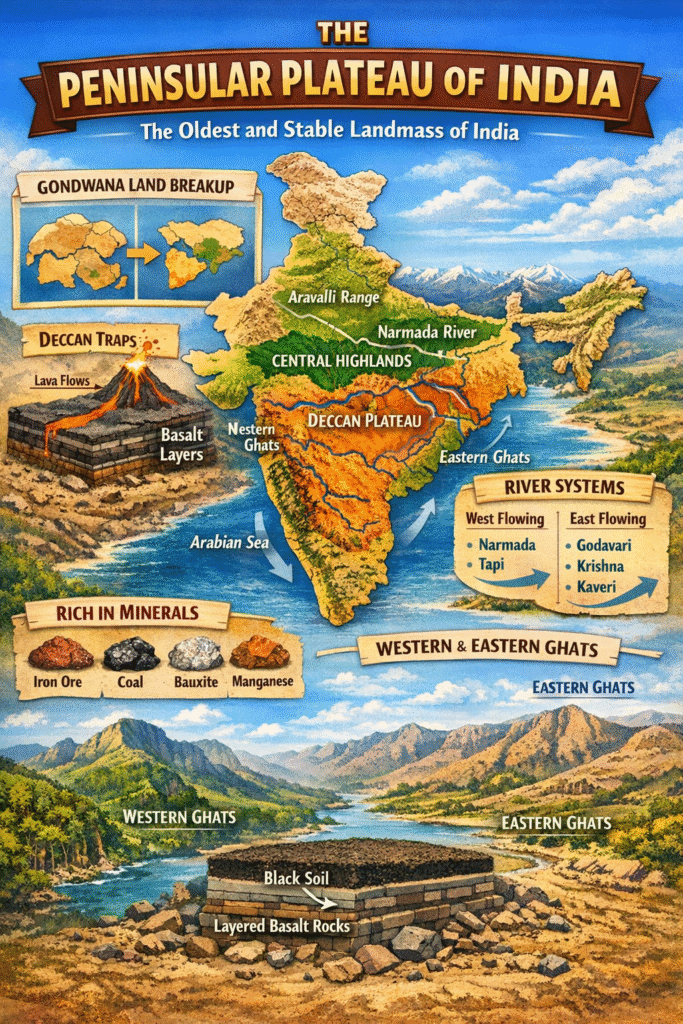
The peninsular plateau is a large triangular tableland covering most of southern India. It is one of the oldest landmasses on Earth, formed during the Precambrian era.
It is often called the “Old Crystalline Plateau of India.”
The peninsular plateau was part of the ancient supercontinent Gondwana Land.
Around 200 million years ago:
Because it is tectonically stable, this region does not experience major earthquakes like the Himalayas.
Draw a simple labeled diagram showing:
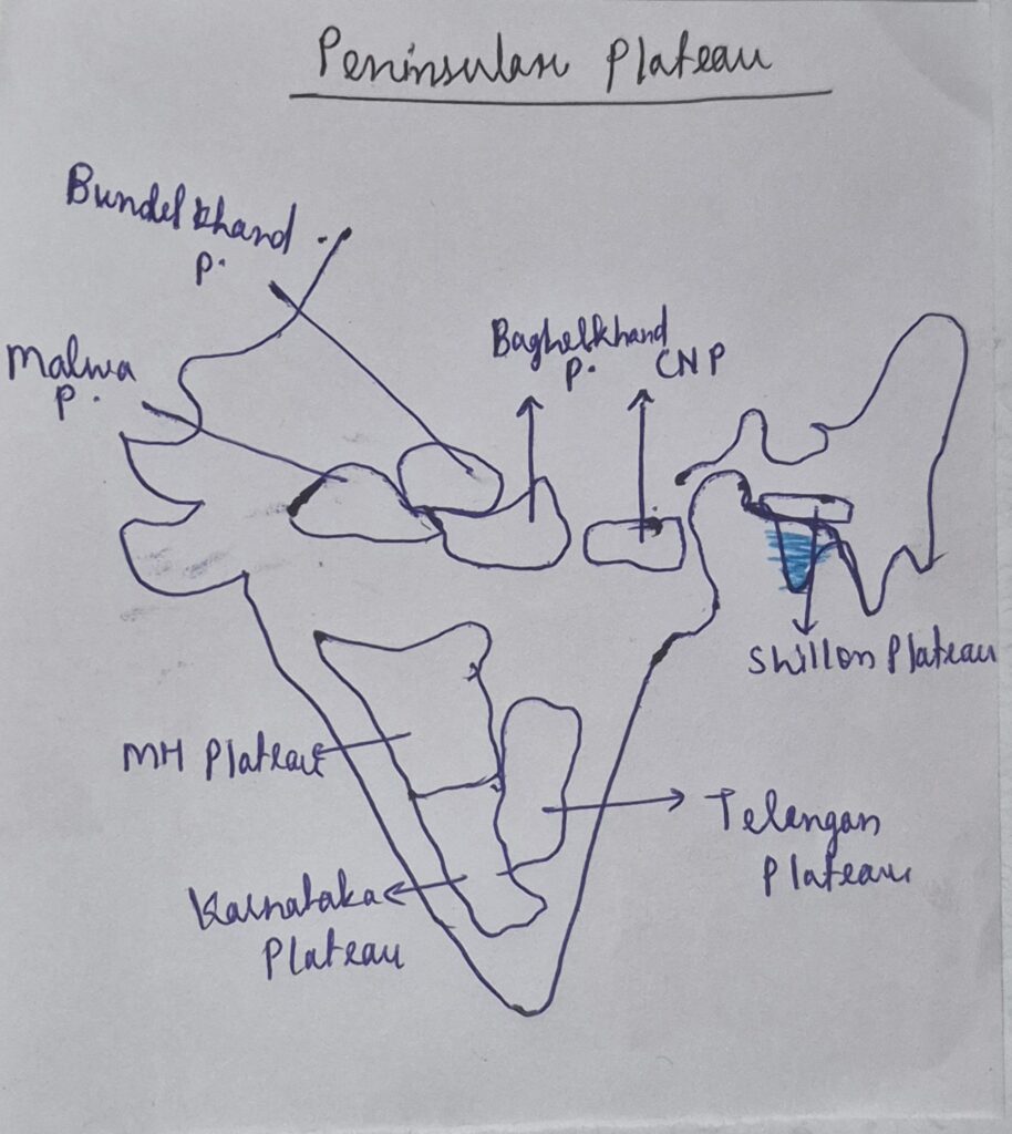
The peninsular plateau is broadly divided into two parts:
Let us understand each clearly.
Located north of the Narmada River, this region slopes towards the north and east.
The Aravalli Range is one of the oldest fold mountains in the world and lies in this region.
Located south of the Narmada River, the Deccan Plateau forms the largest part of the peninsular plateau.
It is triangular in shape.
The plateau slopes from west to east.
The Deccan Plateau is famous for the Deccan Traps.
These are layered basalt rocks formed due to volcanic eruptions.
The black soil (regur soil) found here is ideal for:
The Western Ghats run parallel to the western coast.
Features:
They block monsoon winds, causing heavy rainfall on the western side.
The Eastern Ghats are discontinuous and lower in height.
Features:
The rivers here are older and mostly seasonal compared to Himalayan rivers.
These rivers flow into the Arabian Sea through rift valleys.
They form large deltas before entering the Bay of Bengal.
| Feature | Himalayan Rivers | Peninsular Rivers |
|---|---|---|
| Age | Young | Old |
| Nature | Perennial | Seasonal |
| Valley | V-shaped | Broad & shallow |
| Floods | Frequent | Less frequent |
You can draw this table in your notes for quick revision.
The peninsular plateau is called the “Mineral Heartland of India.”
Major minerals found:
The Chota Nagpur Plateau is especially important for iron and coal.
UPSC often asks questions on mineral distribution — so remember this region well.
The peninsular plateau plays a crucial role in India’s geography and economy.
| Aspect | Peninsular Plateau | Himalayan Region |
|---|---|---|
| Age | Very old | Young |
| Stability | Stable | Unstable |
| Earthquakes | Rare | Frequent |
| Rocks | Igneous & Metamorphic | Sedimentary |
This comparison is extremely important for prelims.
Practice drawing India’s outline in under 2 minutes for mains answer writing.
Make short notes from each section.
The peninsular plateau is the oldest and most stable landmass of India. It was part of Gondwana Land and is rich in minerals. It is divided into the Central Highlands and the Deccan Plateau.
Key revision points:
For UPSC, focus on structure, rivers, minerals, and comparison with the Himalayas.
Mastering the peninsular plateau strengthens your Indian Geography foundation.
Because it is made of Precambrian crystalline rocks and has remained tectonically stable for millions of years.
They are volcanic basalt formations found in the Deccan Plateau formed due to lava eruptions.
Narmada and Tapi rivers flow west into the Arabian Sea.
It is composed of ancient igneous and metamorphic rocks that contain metallic minerals like iron and manganese.
Western Ghats are higher, continuous, and block monsoon winds, while Eastern Ghats are lower and discontinuous.
If you are preparing for UPSC or other competitive exams, revise this topic with maps and diagrams. The peninsular plateau is not just geography — it is the backbone of India’s physical structure.

[…] strongest core is usually located over peninsular India, […]